aschmann.net; via GG on Faacebook
|
(12-Aug.-2014)
|
Sections
Dialect Survey of Individual Words(27-June-2013)
Many of you have written in to ask, “What about such-and-such a word? What is its distribution across North America?” And my answer has always been, “That’s not what this map is about, it’s about sound patterns affecting many words at once, it’s about phonemic patterns.” Not that I’m not interested, I am, it’s just that there is no place for this sort of information on my map.
However, finally someone has done just what many of you have wanted, they have mapped the distribution of lots of these individual words, as well as some grammatical constructions, and you can enjoy browsing through them here. If you don’t want to struggle through the whole list, a selection of some of the most interesting with whimsical comments can be found here. 21-Aug.-2013
Sadly, they still don’t have some of the ones I’m interested in, like “greasy/greazy”, which has a north-south distribution similar to “on”! Does anyone know of one? 19-Aug.-2014
The link for this site was sent in by Joshua Katz. Thanks! Also, Joshua has redone the maps to make a lot of them more readable, as for example his map of words for carbonated beverage. 1-July-2013
|
This is just a hobby of mine, that I thought might be interesting to a lot of people. Some people collect stamps. Others collect coins. I collect dialects. - Rick Aschmann. (Page last updated: September 1, 2015.)
Thanks to all of you who have written expressing appreciation for the page! I don’t promise to respond to every e-mail, but I am still trying to answer all those who sent in a sample or other information, or even a complaint. Unfortunately, my life is always very busy, and I can only dedicate a small portion of my time to this, so I have trouble even keeping up with current correspondence about this page. Worse yet, from time to time this page gets posted to another popular blog, and I get a new surge of e-mail, so I have doubts of ever being able to answer it all. But I’ll keep working at it! 12-Aug.-2014
There are 8 major English dialect areas in North America, listed below the map at left. These are shown in blue, each with its number, on the map and in the Dialect Description Chart below, and are also outlined with blue lines on the map. The first 6 of these begin at the eastern seaboard and proceed west, reflecting western settlement patterns.
The many subdialects are shown in red on the map and in the chart, and are outlined with red lines on the map. All of these are listed in the margins of the map as well.
In the Dialect Description Chart additional features not shown on the map are provided for distinguishing the dialects.
Recent additions
• Continuing survey: I only discovered in 2011 that many if not most Americans pronounce the “l” in words like “calm” and other words ending in “-alm”, which surprised me very much, since I don’t. Some also pronounce the “l” in “folk”, and even a few may pronounce the “l” in “talk”. See The Pronunciation of “-alm” and “-olk” and “-alk” for more details. I would love to know if you do or do not pronounce the “l” in such words, and where you grew up! Yes, I know many of you have sent in data, and I am still trying to get it all compiled. One thing that has discouraged me is that so far no very discernible pattern is emerging! 8-Dec.-2014
What’s New? All additions or changes within the last two or three months are marked with “ New! ” and the date, or with “ Adj. ” (for “Adjusted”.) To see this new information, simply search for these words.
Map Format
I have made a number of adjustments to the map format based on comments and suggestions from people who write in. However, the main complaint, that the map is too complicated and confusing, I can’t really fix: the subject is complicated, and I am well aware that I have tried to include too many features. However, if people have ideas on how to make the map or web page less confusing, I am all ears! 8-May-2013
One thing that may help is that you can now view the file in layers. 16-Sep.-2014
Most Common Second and Third Languages by State in the U.S.
The following page is interesting, and was pointed out to me by several people, although it probably has no direct correlation to the data presented here: gizmodo.com/the-most-common-languages-spoken-in-the-u-s-state-by-1575719698. 19-Aug.-2014
Web-Based Survey now completed
A group of linguists had been gathering data on North American English dialects using a web-based survey. They asked for our help, and some of you helped with this survey. This survey is now closed, with 3903 total responses in December 2012. You can see some preliminary results at: pantheon.yale.edu/~clb3/NorthAmericanDialects.
However, I find that some of their samples definitely do not represent the local dialect! 26-Dec.-2012
|
| |||||||||||||
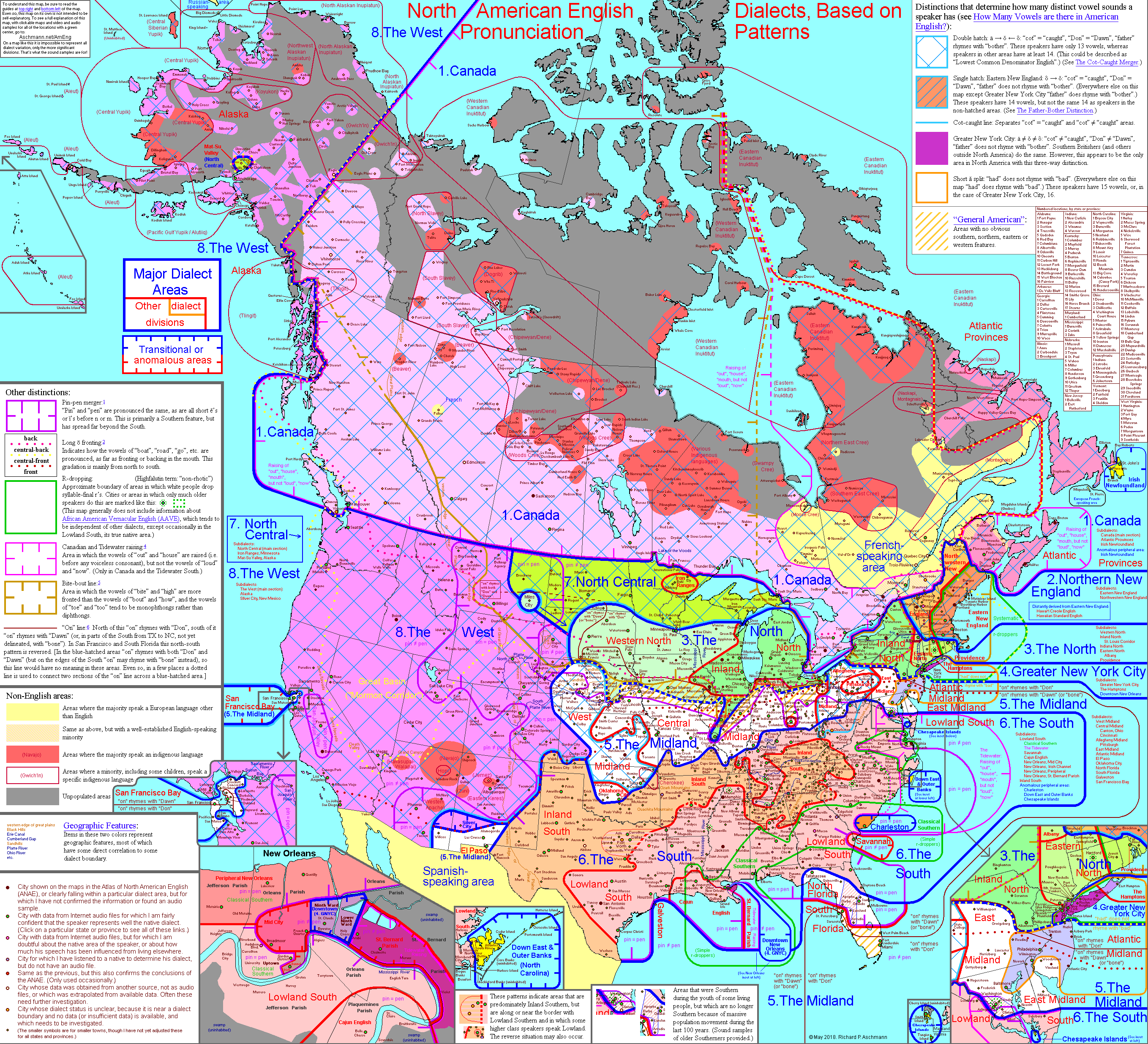
Small-Scale Dialect Map
The small map below is the same as the Full-Scale Dialect Map that follows, but shows the entire width of the map (on most monitors). 24-Aug.-2010
Click on any part of this map to move to the equivalent part of the Full-Scale Dialect Map. (For now this only moves to the far left or the far right of the Full-Scale Dialect Map, so unfortunately it doesn’t work well for the middle portions, and you will just have to scroll over.) 24-Aug.-2010
Full-Scale Dialect Map
Instructions
For many of the cities or towns on this map, you can listen to an audio or video sample of speech of a native (more specifically, someone who was raised there, though not necessarily born there, and whose dialect clearly represents that place). All of the cities or towns with a green center have such an audio or video sample that can be listened to (and a few of the ones with pink centers do also). I will continue adding new audio and video samples, so check back from time to time. So far there are over 900 samples listed, more and more of which are from contributors! Thanks! 1-Sep.-2014
Use the scroll bars to move around on this map, or, even simpler, start at the tiny map above and click the country (U.S. or Canada) that you want to look at. This will take you to the Small-Scale Dialect Map. Click again to zoom in further on your location. (For now this only moves to the far left or the far right of the Full-Scale Dialect Map, so unfortunately it doesn’t work well for the middle portions, and you will just have to scroll over.) 24-Aug.-2010
The entire map is clickable, taking you to the list of samples for that state or province. Only those locations with green centers, and a few with pink centers, have a sample so far. There will be a few areas of the oceans and the legends that are not clickable, but all of the states and provinces now are. Place the mouse over a particular state or province to see its name. (The map guides, showing the meaning of all the colors, are on the top right and bottom left of the map.) 25-Sep.-2013
Help! For many places I haven’t found an audio sample yet. If you know of an audio or video sample on the Internet that features a speaker who was raised in a particular place, and whose dialect clearly represents that place, please let me know, whether that place is currently listed or not! Although many of the people in these samples are prominent people, I actually prefer ordinary local people, but anyone at all will do, as long as their pronunciation represents the local dialect. (The ones I especially need, and cannot find, are those with an orange-yellow center.) Also, if you think that one of the audio examples does not truly represent the local dialect, please let me know in the same way. (Oh, but please keep the samples clean. I have a policy of not using a sample if it uses a word you can’t say on TV in the U.S.!) I will normally list your name as the contributor, to make this more of a community project, unless you’d rather I didn’t, in which case I will use initials. However, I will not publish anyone’s e-mail address. 10-May-2011
Numbered Locations: Thanks mostly to enthusiastic contributor Eli K. in 2010, much of Kentucky and Tennessee and neighboring areas are about as thoroughly mapped as they possibly can be. That’s the kind of help needed to really fill out this map! In fact, I was forced to go to a numbering system for such areas, since the scale of the map is already big enough! I put the key to the numbers off the east coast of Canada. 1-Se
No comments:
Post a Comment